top of page
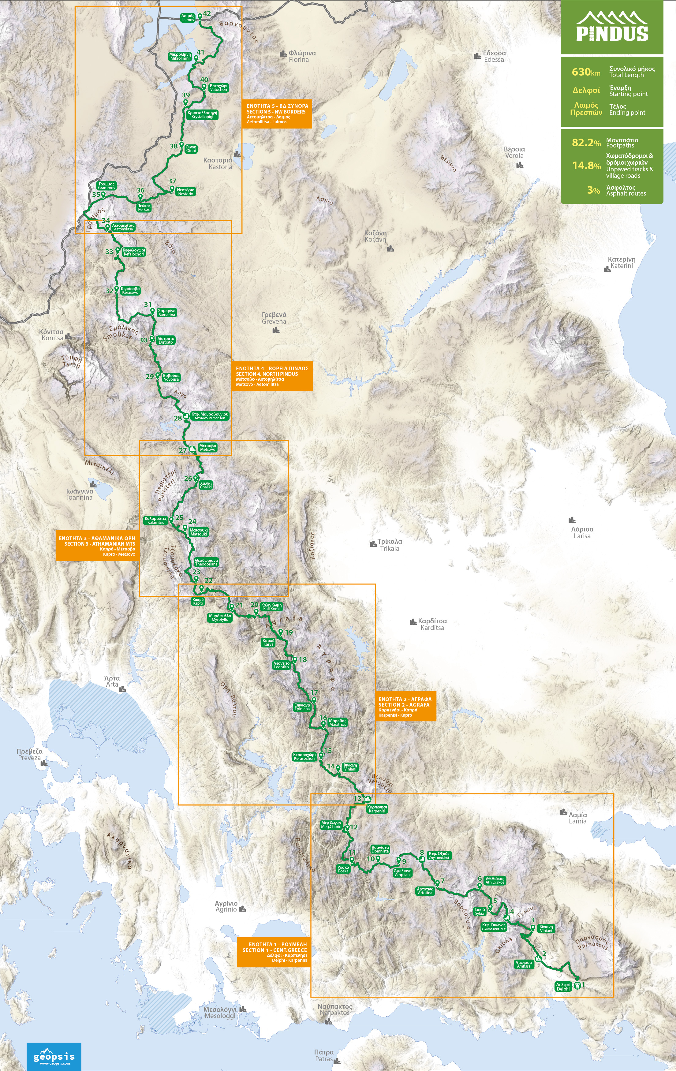
Οι γεωγραφικές ενότητες του Pindus Trail
Η διαδρομή αποτελείται από 41 διαδοχικά ημερήσια τμήματα στον άξονα και διακλαδώσεις πολλαπλής επιλογής, που εντάσσονται σε 5 μεγάλες γεωγραφικές ενότητες.
Στους παρακάτω χάρτες μπορείται να δείτε τις χαράξεις των διαδρομών ανά ενότητα, όπως και το συνολικό ανάπτυγμα τους στην έκταση της οροσειράς.

1. Ρούμελη (Δελφοί - Καρπενήσι)
Η 1η ενότητα βρίσκεται στο νότιο σκέλος της οροσειράς, εντός των ορίων της ιστορικής και γεωγραφικής Ρούμελης. Η χάραξη της διαδρομής αναπτύσσεται κατά τόπους σε 2 κλάδους και συνδέει τις απολήξεις του Δυτικού Παρνασσού, τη Γκιώνα, την κοιλάδα του Μόρνου, τα Βαρδούσια, τη Σαράνταινα και την Καλιακούδα για να καταλήξουν στο Καρπενήσι, κάτω από το Βελούχι. Διαβάστε περισσότερα.

2. Άγραφα (Καρπενήσι - Καπρό)
Η 2η ενότητα εκτείνεται στην ευρύτερη οροσειρά των Αγράφων εντός των γεωγραφικών ορίων της Στερεάς Ελλάδας και της Θεσσαλίας. Η σύνθεση της διαδρομής συνδέει το Καρπενήσι με την κοιλάδα του Μέγδοβα, το βουνό Καυκί, την κοιλάδα του Αγραφιώτη, το φαράγγι του Ασπρορέματος, το Ντεληδήμι, τα Βερούσια όρη και την Καλή Κώμη. Στην προέκταση των Αγράφων, διατρέχει την κοιλάδα του Αχελώου και το όρος Χατζή. Διαβάστε περισσότερα.

3. Αθαμανικά Όρη (Καπρό - Μέτσοβο)
Η 3η ενότητα διέρχεται από το σύμπλεγμα των Αθαμανικών Βουνών εντός των γεωγραφικών ορίων της Ηπείρου και της Θεσσαλίας.
Η χάραξη αναπτύσσεται σε 2 κλάδους διάσχισης της ευρύτερης περιοχής, συνδέοντας το όρος Χατζή με τα Τζουμέρκα, τα χωριά του ασπροποτάμου, την Κακαρδίτσα, τα παραδοσιακά βλαχοχώρια του Λάκμου (Περιστέρι) και την κωμόπολη του Μέτσοβου. Διαβάστε περισσότερα.

4. Βόρεια Πίνδος (Μέτσοβο - Αετομηλίτσα)
Η 4η ενότητα διέρχεται από τις κατάφυτες δασικές εκτάσεις της βόρειας Πίνδου, αναπτύσσοντας 2 κλάδους διάσχισης στα γεωγραφικά όρια της περιφέρειας Ηπείρου και της Δυτικής Μακεδονίας.
Οι χαράξεις συνδέουν την κωμόπολη του Μετσόβου με τα όρη του Λύγκου, τη Βάλια Κάλντα, την κοιλάδα του Αώου, τη Βασιλίτσα, την Γομάρα, το 2ο ψηλότερο βουνό της χώρας τον Σμόλικα, το όρος Ταμπούρι (Οχυρό), τον Σαραντάπορο ποταμό και την Αετομηλίτσα του Γράμμου κοντά στα ελληνοαλβανικά σύνορα. Διαβάστε περισσότερα.

5. Βορειοδυτικά σύνορα (Αετομηλίτσα - Λαιμός)
Η 5η ενότητα της χάραξης κινείται εξ ολοκλήρου στα γεωγραφικά όρια της Δυτικής Μακεδονίας και συνδέει τον Γράμμο στη βόρεια απόληξη της οροσειράς της Πίνδου με τις λίμνες των Πρεσπών. Η διαδρομή διατρέχει το μήκος των Βορειοδυτικών σύνορων της χώρας από ημιορεινές περιοχές και βουνά περιμετρικά των λιμνών. Η χάραξη περνά από ακριτικά χωριά διαμέσου του όρους Τρικλάριο, της μικρής Πρέσπας, του Βαρνούντα και του Λαιμού των Πρεσπών στα σύνορα με τη Βόρεια Μακεδονία. Διαβάστε περισσότερα.
Χάρτης ολόκληρης της διαδρομής
bottom of page